NEW FRONTIER IN PRODUCTION OPTIMIZATION: LAST MILE ‘JUST-IN-TIME’ RESOURCING
In spite of resource planning teams and experienced field crews, containing issue response time and cost of response remain elusive. The field is plagued with bad weather, poor road conditions, over-booked vendors, uncertain job times, varying types of issues, unforeseen need for parts and lack of matching skills. To make up for high levels of uncertainty traditional field planning overshoots on 70% – 80% oilfield jobs. On average, companies shell out $300 per hour as the crew often waits to complete jobs. That gap in planned vs. actual time to response results in an expensive non-productive time of vendor and employee crew alike. Worse yet, this prevents oilfields from being consistently nimble in their response to high priority issues. Without truly being able to visualize crew proximity to issues, last-mile ‘just-in-time’ resourcing was more of a fantasy.
Yesterday’s fantasy is today’s reality. ‘Uber’ like algorithmic visibility of resources allows oilfields to play catch up to other industries such as taxis, restaurant deliveries, retail and manufacturing that have capitalized on ‘just-in-time resourcing’.
ACTIONABLE LAST-MILE RESOURCE VISIBILITY
Most oilfields have been tracking resources for a while now through trackers on trucks, laptops, or any other corporate asset. Why has such data not already been used to do ‘just-in-time’ resourcing of vendors and field crew?
The answer revolves around data. While these trackers do provide resourcing locations, the data was never engineered with an intention to drive ‘just-in-time’ resourcing. The old generation trackers on trucks, laptops, etc. were developed to do just that, track. Not to respond. That’s the big difference. So, companies looking to harness their last generation GPS trackers have had to do data gymnastics and complex integrations that were neither real-time nor responsive.
True real-time resource visibility requires three critical elements to come together. One, that the device is as much as possible with the resource (mobile phone). Two, geodata is algorithmically siphoned (fenced) in relation to critical assets identified by oilfield leadership. Three, data automatically feeds back to planners and field crew as smart communications such as proximity alerts and notifications.
Now let us apply this to a simple oilfield scenario. A lease operator is on a scheduled well visit and is alerted to the next proximal resource to support a roustabout crew. Either a planner issues that alert or task or it is automatically issued based on proximity awareness. That cuts down the usual hour wait time for a $500/crew member of a five-member roustabout crew. Time to response and the cost of response no longer needs to outweigh the actual fix time and cost.
Layer this simple example with the myriad of preventative maintenance, installations, inspections and other multi-crew coordination that happen all day long. Planners, supervisors and field crew no longer need to wait until tomorrow or even end of the day to experience a reduction in response time. Over time, oilfields will also be able to measure increased production time in relation to response times.
NUTS AND BOLTS OF ACTIONABLE VISIBILITY: REALTIME GPS AND GEOFENCE TAGGING
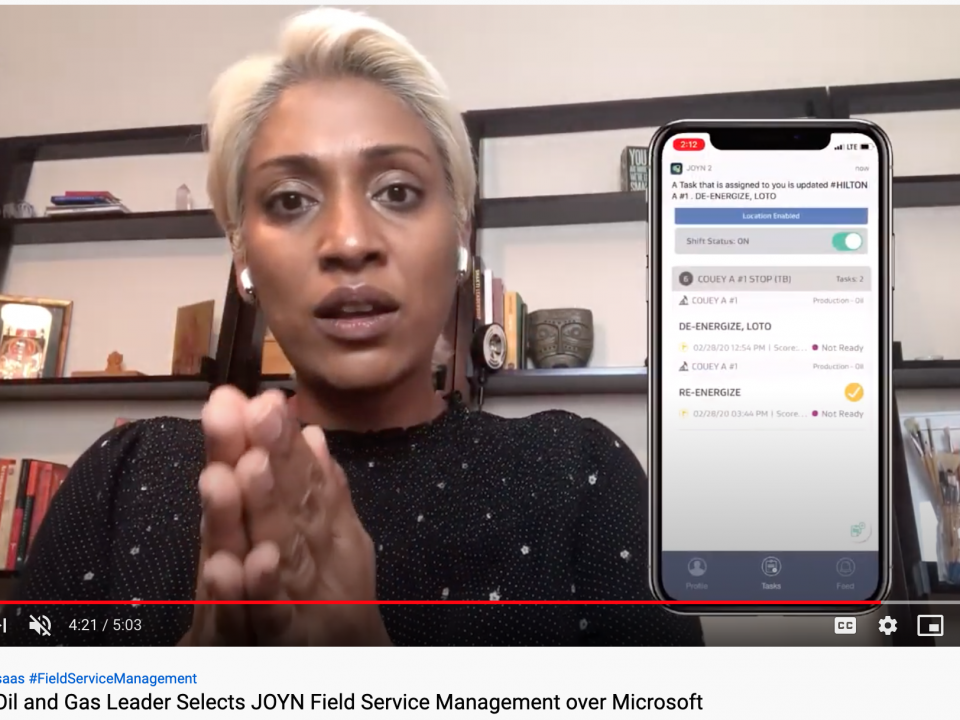
Actionable visibility sounds abstract until we dive deeper to find out what that actually means to the field. Based on real-time GPS attached to their production data being entered, foremen today can observe their teams on a LIVE map and putting their wins (production numbers) on the board. They no longer are waiting till the end of the day to get those numbers and can course-correct their team immediately if needed. JOYN is the first and only integrated mobile platform that bridges this visibility gap and makes collaboration a breeze. JOYN equips the field office to track live routes and follow the location of every field worker, real-time.
The supervisors can follow each field worker, sitting in the office, on satellite maps. Now they know if the assigned lease operator is too far from the well where a crew is waiting for inspection. They can route the nearest operator to the spot to reduce delay and cut down response time for high priority issues.
The supervisors never lose sight of their field as advanced geofencing and GPS tracking keeps them in touch with each and every field worker, without interrupting the field with multiple phone calls and texts. And it gets better. The data is not lost even in areas with no connectivity – an intuitive auto-sync captures data while offline and syncs up automatically when the lease operator’s device has connectivity. The field office now tracks, flags exceptions and communicates without delay.
The fields are safer and more compliant as workers within a geofence are alerted on time during exigent situations. For instance, if there is a high H2S alert on a well, the workers within the geofence can be immediately alerted to move out. Also, in cases of accidents or mishaps, the route record is easily verified.
REAL-TIME PRODUCTION VOLUMES IMPROVE PRIORITIZATION
Now combine Live Tracking with a Dynamic Routing Engine that senses resource proximities, and responds immediately to highest priority tasks as prescribed by field leaders and ad-hoc tasks requests. JOYN equips field offices to act upon the granular detail that previously was not fused together – time spent on each stop, drive times, well times, wrench time, production numbers and much more. Field offices now prioritize high-volume assets over low producing wells with just-in-time resourcing. They improve cash flow by driving down wait times. This is today’s reality.
Seven Lakes Technologies has built Live Route with HyperTrack, a San Francisco based API company that develops proprietary technologies on the OS, maps, and cloud to generate accurate, battery-efficient and real-time movement data. Read more here.